
|

|
|
| |
Thursday, 19 February On to Wanaka
The promised 0730 pick-up at the hostel didn’t happen until 0745, then we toured around the hotels picking up more passengers and it was quarter past eight before the bus hit the road. Amongst these later passengers was a Scottish couple, the lady sat beside me and tried to strike up a conversation but was discouraged by my monosyllabic responses and gave up, leaving me to enjoy the run down through the Kawarau Gorge.
We stopped for a quarter of an hour at Jones Fruit Stall, just before Cromwell; I bought some apples here ten years ago. After Cromwell we turned north beside the Clutha River where it flows through Lake Dunstan. This has been much enlarged by the construction of the dam at Clyde some 25 kilometres downstream. I tried a couple of photographs from the bus but there were many reflections.
|
|
|
|
| |
We were on time at Wanaka at ten past ten (the bus goes on over the Haast Pass to Franz Josef) and I wandered along the lake shore admiring the view, then up to the hostel. The manager was not about but there was a list of room allocations so I dumped my bag on an optimum bed (lower bunk beside a window) then walked back into town for brunch (tea, steak and onion pie and a ham salad roll) at the Penguin Cafe.
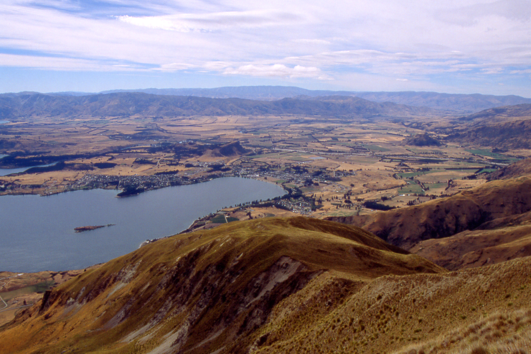
By now it was only half past twelve and I decided a walk was needed to fill the afternoon so I set off along the east shore of Lake Wanaka. I stopped at Eely Point for half an hour, admiring the view (at the risk of repeating myself, I do like Lake Wanaka), before continuing round Beacon Point and along to where the lake drains into the Clutha River. I followed this downstream for a couple of kilometres to the first bridge (SH6) at Albert Town then returned towards Wanaka along the road, reaching the DoC office about half past four to check track information (and buy the relevant map).

|

|
|
| Roy’s Peak (1578m) |
Treble Cone (2058m) skifield |
I bought some food and returned to the hostel to check in for three nights before wandering round the town and having a few beers in Barrows which I remembered from my previous visit though it seems to be in a different place.
Friday, 20 February Roy’s Peak
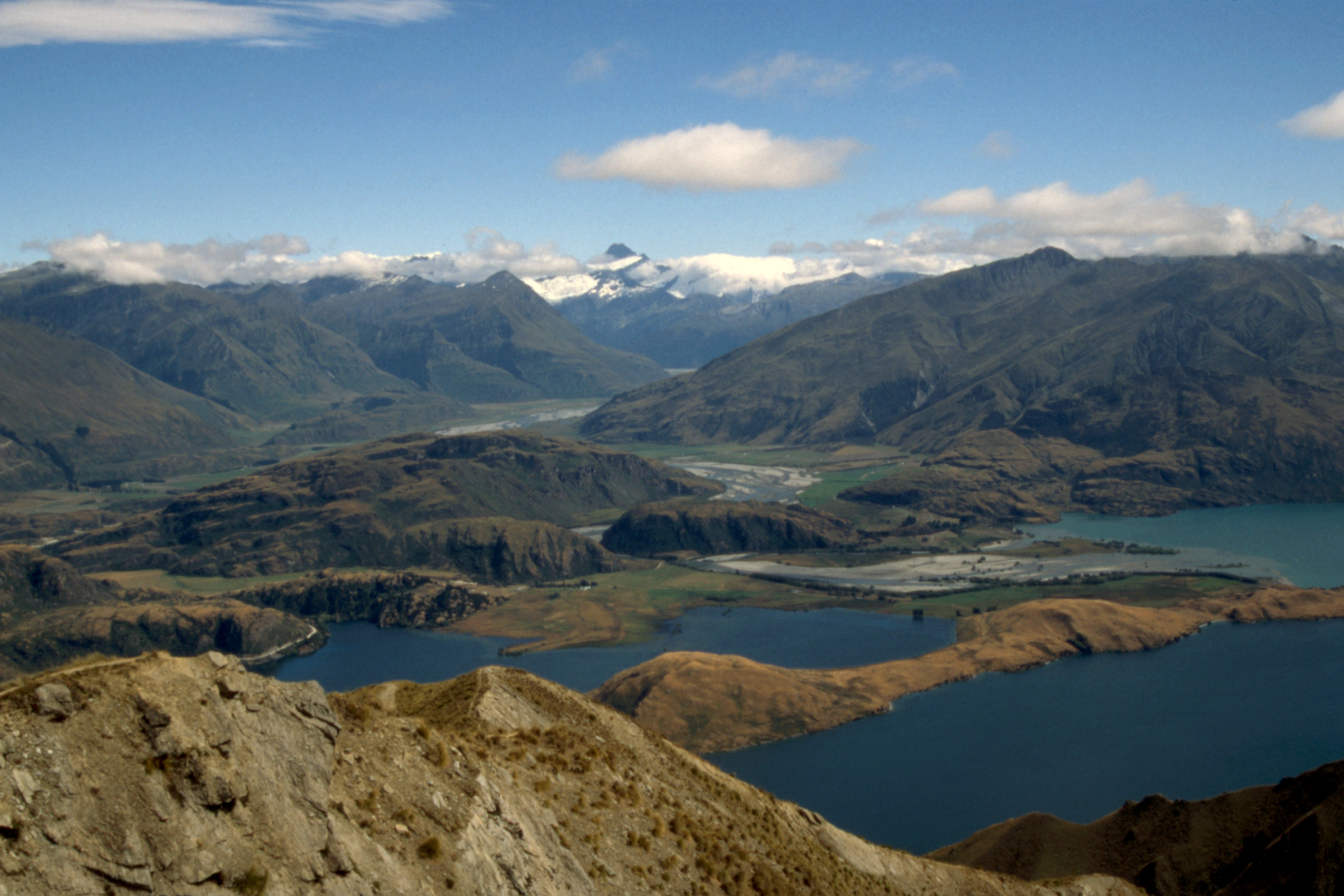
After a light breakfast, I hit the road about half past eight and made good time over the six kilometres to the car park at the foot of the track to Roy’s Peak (1578 metres). There is a wee memorial there to the man responsible for the erection of the local TV transmitter at the top of the hill and for most of the way, the track is a minor estate road which can take a 4-wheel drive at a pinch. So it was a steady slog zigzagging uphill with just one break for photographs. The view from the top was excellent, well worth the effort.

|

|
|
| North up Lake Wanaka |
Dublin Bay & East Wanaka | Wanaka |

|
|

|
| North up Lake Wanaka |
Matukituki River towards Mt Aspiring (3033m) | Wanaka |

|

|

|
| Glendhu, Parkins and Paddock Bays | West across the Motatapu River valley towards End Peak (2100m) |
The summit of Roy's Peak (1578m) |
The descent was reasonably fast and I stopped for a few minutes near the bottom at the grave of a former landowner and his daughter (who had died a month later). The round trip had taken four and a quarter hours as against the four hours minimum quoted on the board at the bottom. I’d have beaten it if I hadn’t stopped at the top — but then I’d have no photographs!
I refused an offered lift back to Wanaka and about half way back, cut down to the loch side at Waterfall Creek (the waterfall must have been above the road as I didn’t see one) and had a much more pleasant stroll back than the outward journey, and was back in Wanaka at half past three. That gave me plenty of time to do some washing before dining on minted lamb in Paddy’s Bar and finishing with a beer in Bullock’s, leaving just before the band started. I hope they didn’t take it personally.
Saturday, 21 February
Time for a bit of sybaritic living after yesterday’s efforts so I had breakfast in a cafe by the loch side and bought some tobacco before wandering 20 minutes up the road to Mt. Iron, a mere 549 metres above sea level but only about 250 metres above Wanaka. The hill was named by the first runholder in the area who came from Ironhurst, Dumfries where his father was the laird (allegedly).
It was an easy walk up and the views around were interesting. I descended the far side and came back round the base. Ninety minutes including the half hour at the top.

|

|

|
| Hawea Flats & Grandview Mountain |
Cardrona Valley | Wanaka |
Back in Wanaka at twenty to two, I partook of a late lunch in Bullock’s, a packet of crisps and a couple of jugs of beer. Then I went to the nearby supermarket for some shopping and as I came back out, it started to rain so I had to run back into the pub for shelter before returning to the hostel for tea.
In the evening, I headed for Paddy’s to be entertained by the Kinlochard Ceilidh band, on a tour sponsored by the British Council. I was not impressed. They were competent players but they turned up at the time the performance was supposed to start so it was forty minutes after the advertised time before we heard any music. Their sound system was not particularly good (apart from being too loud) and the gaps between the sets were almost as long as the sets themselves with no links, as if they had no programme planned. I left in time to be in bed by eleven.
Sunday, 22 February To the West
Phoned home, all is well. I headed for the bus stop to resume my journey to the West Coast. The bus was fairly full but I managed to get a window seat on the better side — the sea side later in the journey. The driver change just over the top of the Haast Pass was well timed, the contrary bus appeared about one minute after we pulled in. There were stops at Makaroa (for elevenses), Thunder Creek Falls (to admire the waterfall), Haast (fuel), Arnott and Knights Points (to admire the coastal scenery).

|

|
| Thunder Creek Falls |
Arnott’s Point |

|

|

|
| (North) Views from Knight’s Point (South x2)
|
||
There was a bit of rain off and on during the journey; it was off when we arrived at Fox Glacier about quarter past three. I booked in to the Fox Glacier Hotel for three nights, a room in the main building with toilet and shower but no TV, phone or tea/coffee facilities. I went for a bit of a wander around the township, dropping into the DOC ranger station to check the local tracks (the road to the glacier has been washed out but is passable on foot) then sat in the bar drinking Monteith’s Original until it was time for dinner.
I opted for the table d’hôte, corn and chicken soup, breaded hoki with various vegetables and pavlova for desert, washed down with a bottle of Longridge Oak Aged Sauvignon Blanc. A reasonable spread. The other main course choices were roast of the day and chicken. A final jug of Monteith’s Black then bed.
Monday, 23 February
Rain. A boring day; I managed to drink not very much but had to eat twice and go to bed early to achieve it.
Tuesday, 24 February
Which was just as well as I was up at ten to five and set out at five past for Lake Matheson. The stars were excellent but I think the Milky Way is more extensive in the northern sky. By the time I’d cleared the street lights, a small crescent moon had lifted above the hills and I was casting a discernible shadow on the road. The occasional shooting star added to my enjoyment of the walk.
After a while, I began to wonder where the turning was for Lake Matheson; it seemed a bit further than I’d expected. Then I came to a bend in the road – that was definitely wrong so I checked the map and it took forty minutes to walk back to the turning! How time flies when you are enjoying yourself. I’d been so busy watching the sky that I’d passed the first side road unnoticed and didn’t bother checking the signpost at the second one (it was too dark to read easily).
Anyway, I got to the head of the lake at quarter to eight, the view was still good but not brilliant. Och well. I completed the circuit of the lake and had breakfast in the cafe which has appeared in the car park since my last visit. Tea and yesterday’s chicken and salad roll (cheap). A welcome snack.

|

|

|
| Early morning at Lake Matheson with Mts Tasman (3498m) and
Cook (3764m) in the distance |
||

|

|
| Mts Tasman (3498m) and Cook (3764m) |
Another mountain |
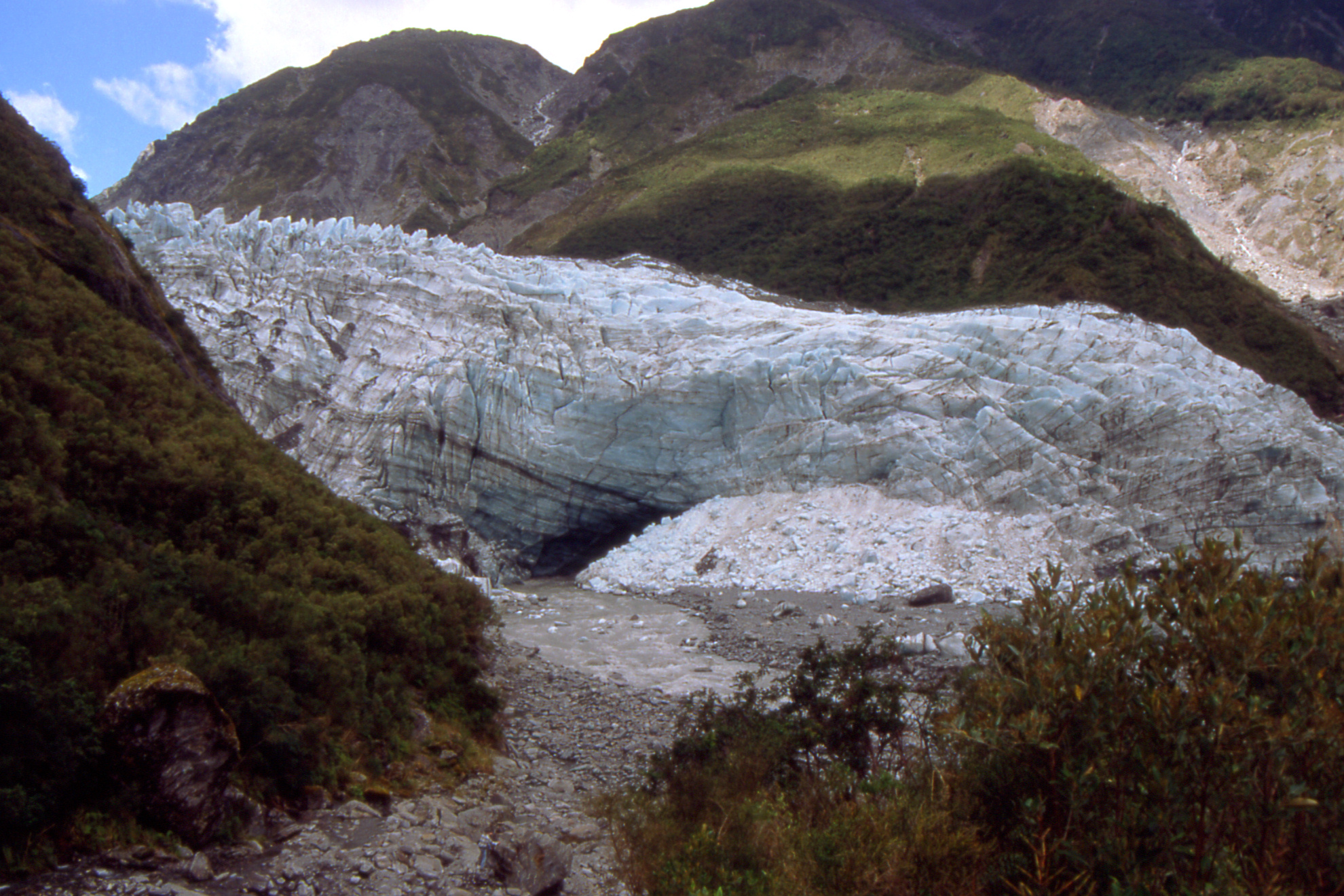
I was back at the hotel at ten past ten, had a quick shower and hit the road again for the glacier. The best views are to be had from Cone Rock on the south side of the valley but the track up that is now considered dangerous so I continued past it and headed for the Chateau Lookout. I had a small problem crossing Mills Creek, couldn’t see anywhere to get across dry-shod so following the example of another couple, took my boots off and waded. While I was putting the boots back on, three Japanese lads leapt across about ten metres upstream. I had a look at that spot on the way back half an hour later and decided to paddle again.

|

|
| The snout of the glacier from the Chateau Lookout
|
|

|

|
|
| The snout of the glacier from the end of the track
|
||

|

|

|
| White Creek? |
Chateau Lookout | Cone Rock |

|

|

|
| The snout of the glacier from further away, and even
further |
||
From the car park
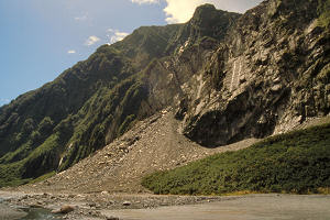
The landslide The car park was closed: there had been a landslide which appeared to have caused a washout of the road (below, right). There was a shuttle bus running from the main road but rough tough Scottish mountaineers scorn such devices and I walked.

|

|

|
| The landslide |
Who nicked the road? | |
On the way back down the valley, I crossed the “historic” (1923) bridge and returned up the north side past the washed out car park to the face of the glacier. The “Danger - do not pass this point” notice was well back from the face but I took a couple of photos anyway and finished the film on the way back down the valley.

|

|
| Upstream from the bridge |
The bridge |
Back in Fox, I sank a quick couple of jugs for medicinal purposes (re-hydration) and had a shower before dining. It was a buffet this evening, I skipped the chicken and corn soup, had beef and lamb with veg and boiled potatoes followed by a plate of salad for my main course and cheesecake and fruit salad for desert. Apparently it’s table d’hôte if there are few folk around, a buffet if there’s a lot of folk (a coach party this evening) and à la carte somewhere in between.
Wednesday, 25 February Mount Fox
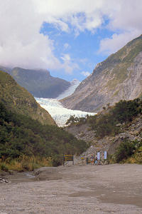
After breakfast in the hotel ($10.50) – a continental buffet offering a selection of cereals, fruits, yoghurt with tea and toast, I ambled along to the Mt. Fox track and started up about ten past nine. After about two and a quarter hours slogging up a muddy track through trees and bush, I reached a trig point at 1021 metres which is marked as Mt. Fox on the map but isn’t a even a top, just the end of a spur with no view of the glacier. I had to continue another forty minutes and 200 metres for a decent view but it was well worth it. The track had faded but there was still plenty of climbing ahead. However, I chickened out.

|

|

|
| Cook & Fox Rivers head for the sea |
Fox River & Fox Glacier township | Fox Glacier township |

|

|
| Fox Glacier from 1220m up the Fox Track |
|
I decided to wear my waterproof trousers for the descent, expecting several close encounters between my posterior and the mud, but it wasn’t too bad. Back at the road, I stopped by the Thirsty Culvert to wash the mud from my boots and trouser bottoms before returning to Fox. at four o’clock. I had just the one beer before showering and nipping into the Alpine Guides shop in search of a Fox Glacier tee-shirt but they had nothing in my size. It was a buffet again this evening in the hotel so I had beef and lamb again. I said goodbye to Sarah, my waitress, then just one jug before retiring to sort my gear and go to bed.
Thursday, 26 February On to Hokitika
Well, the bill wasn’t too bad as it was just for bed and food, I’d paid for the beer as I went along. For breakfast I had a pint of milk. When the bus arrived, a German girl leapt aboard and dumped her towel, sorry bag, on the front seat. Her face was a bit red as she retrieved it after the driver examined her ticket and explained that this was the northbound bus, the southbound – the one she wanted – would leave from across the road. (And when it did, it would already be full of passengers from Franz Joseph.)
When the bus started, it immediately pulled round to the front of the hotel to pick up more passengers – there had been no need for me to carry my bag to the bus stop. Anyway, at Franz Joseph, the bus filled up — overfilled I think as there was a minibus kept pace with us to Hokitika where someone who had not been on our bus came forward to claim luggage.
We reached Hokitika at twenty past twelve and I took my bag along to the Beach House Backpackers, found a bed and went for a wander around the town. Spotting a likely looking cafe, I had vegetable soup with bread (ordinary pan) and butter and tea for lunch before checking out the Railway Hotel (where I encountered Ward’s ten years ago) but the only beer of any interest which they had was Mainland Dark Ale, and they didn’t know who brewed it. They also had Lion Brown, the first I’ve seen on this trip. It was an expensive establishment compared to the others in the town.
Then it was back to the hostel (which had been unattended when I arrived) to pay for the bed and take tea and a sandwich in the adjoining cafe. Fish and chips for tea then a couple of jugs in O’Conner’s (part of the Southland Hotel) before bed.
Friday, 27 February And so to Greymouth
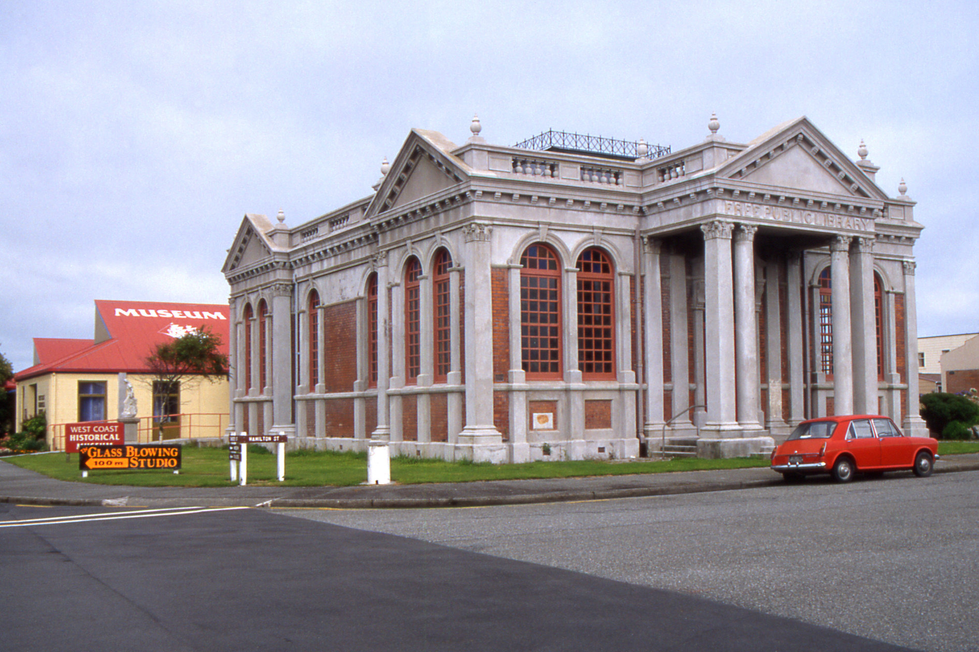
Tea, pie and a sandwich for breakfast in a convenient cafe then a visit to the West Coast Historical Museum, which seemed smaller than I remembered it but was still quite interesting. I tried to photograph the gold mining dredge built with Meccano but the light was not good. We’ll see what comes out.

|

|

|
| |
|

|

|
| Carnegie Library |
Clock tower | Church of the Virgin Mary |
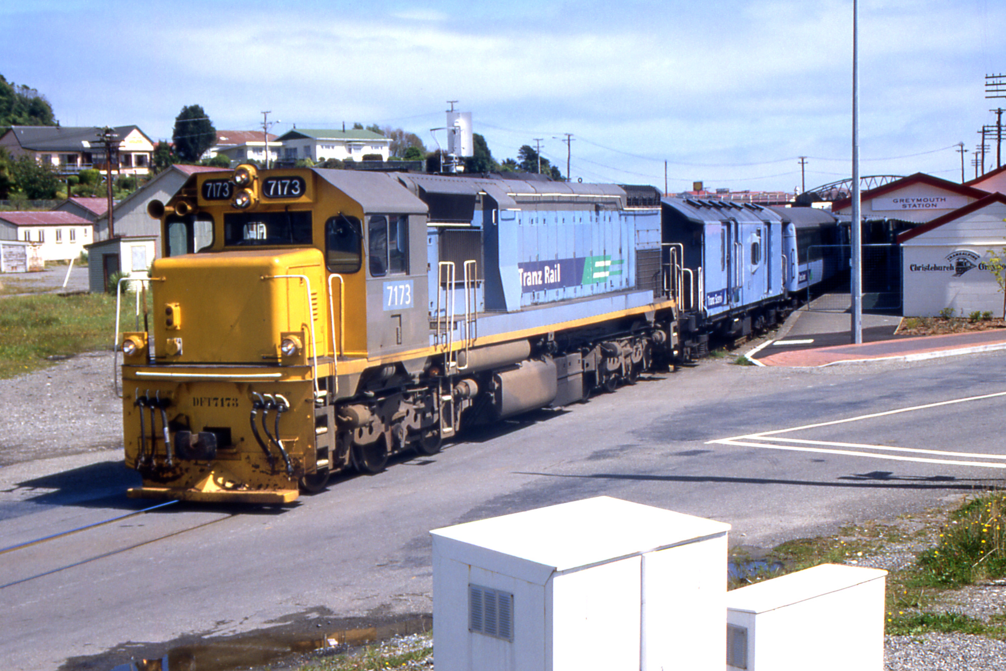
The bus was full leaving Hokitika at quarter to one for the forty minute run to Greymouth where I wandered up to the new Youth Hostel (formerly a Marist Brothers’ house) to check in. Being sensible people, they man the office from one thirty till two thirty as most of the public transport arrives in the middle of the day (i.e. north and south bound buses and the Tranz Alpine (train) from Christchurch. I booked for two nights then went shopping for the usual milk, cheese, biscuits etc. I also bought the ridiculous J31 Greymouth map – a wee corner of land with a vast expanse of sea and only 50¢ less than the standard $12.50 price.

|
|
| Tranz Alpine leaving Greymouth |
|
I checked out the site of the old YH beside the river, now Living Streams Backpackers. There were two floods in 1988 shortly after I visited and there is now an extensive system of flood defences along the river and creeks in the area. Then I found the Recreation Hotel, now with motel units behind it (and left sharply when the Salvation Army came in) but couldn’t find the right takeaway. I bought cheeseburger and chips in another one in the same area but it wasn’t the same. After that, I’d a couple of jugs in the Royal while they were starting a karaoke session. It was pretty civilised, they didn’t suggest I joined in.
[ next chapter ]
John Reynolds — April 2013

