 |
 |
 |
| Kalkite Mountain beyond the Lion & Cub Islands |
The dam which blocks the Snowy River | Sluice gates of the dam at Lake Jindabyne |
 |
 |
 |
| The impoverished Snowy River | Kalkite Mountain above Copper Tom Reach | The dam which blocks the Snowy River |
Friday 28 November — Bundanoon to Jindabyne
The Canberra train was about eight minutes late; but who cares? This was my first trip on Xplorer stock, something between Endeavour and XPT. (In UK, terms, something between a Super Sprinter and an HST but with more leg room, improved suspension and real air conditioning.) The train was a three car set with no obvious unit identification. All seats are rotatable (Australians and New Zealanders don’t like travelling with their backs to the engine), there is a toilet in each car and a buffet in Car A (I didn’t try the sandwiches (having had to eat more than I wanted at breakfast to save carrying perishables) but the tea was hot water, tea bag and UHT milk). There are three trains in each direction each day, timed to require only two sets in service.
We were on time at Canberra but the coach for Cooma did not appear at the scheduled time. I made enquiries and was informed that it started from the bus station in town and was usually a few minutes late. That few minutes turned out to be twenty. The journey was comfortable and we were only five minutes late at Cooma, arriving at ten past two. The “bus station” there is a small waiting room round the back of a filling station on the road into town, about half a mile from the centre. I got off there but as I was walking into the town, the bus passed me - apparently it does continue into the town then back to the bus station.
I went into the Visitor Information Centre to buy maps for the next few days and enquired about transport on to Thredbo. There’s the school bus to Jindabyne at quarter to four or wait till Monday. From what I’d already seen of the town, a weekend in Cooma might get a little boring by about ten o’clock on Saturday morning so I crossed the road to the travel agent who handled bookings for the school bus. Jindabyne might turn out to be worse but at least it was nearer the hills.
There was time for a couple of beers before the bus, which was very quiet given that it was half full of teenagers. I didn’t complain. Most of the passengers got off along the route. We reached Jindabyne just after half past four and I headed for Lazy Harry’s cheap accommodation but it was closed till just before New Year. I would just have to go upmarket. The nearest place, a motel called Kookaburra Lodge, was quoted in the guide book at from $40, well I could manage that for one night. When I enquired the price, it was $25 including a light breakfast so I booked for two nights.
The room was small, just large enough for two two-tier bunks, a table and four chairs, television, toilet and shower. There was no kitchen but a kettle with tea, coffee and some packets of biscuits was provided. Time for a shower while the tea was brewing.
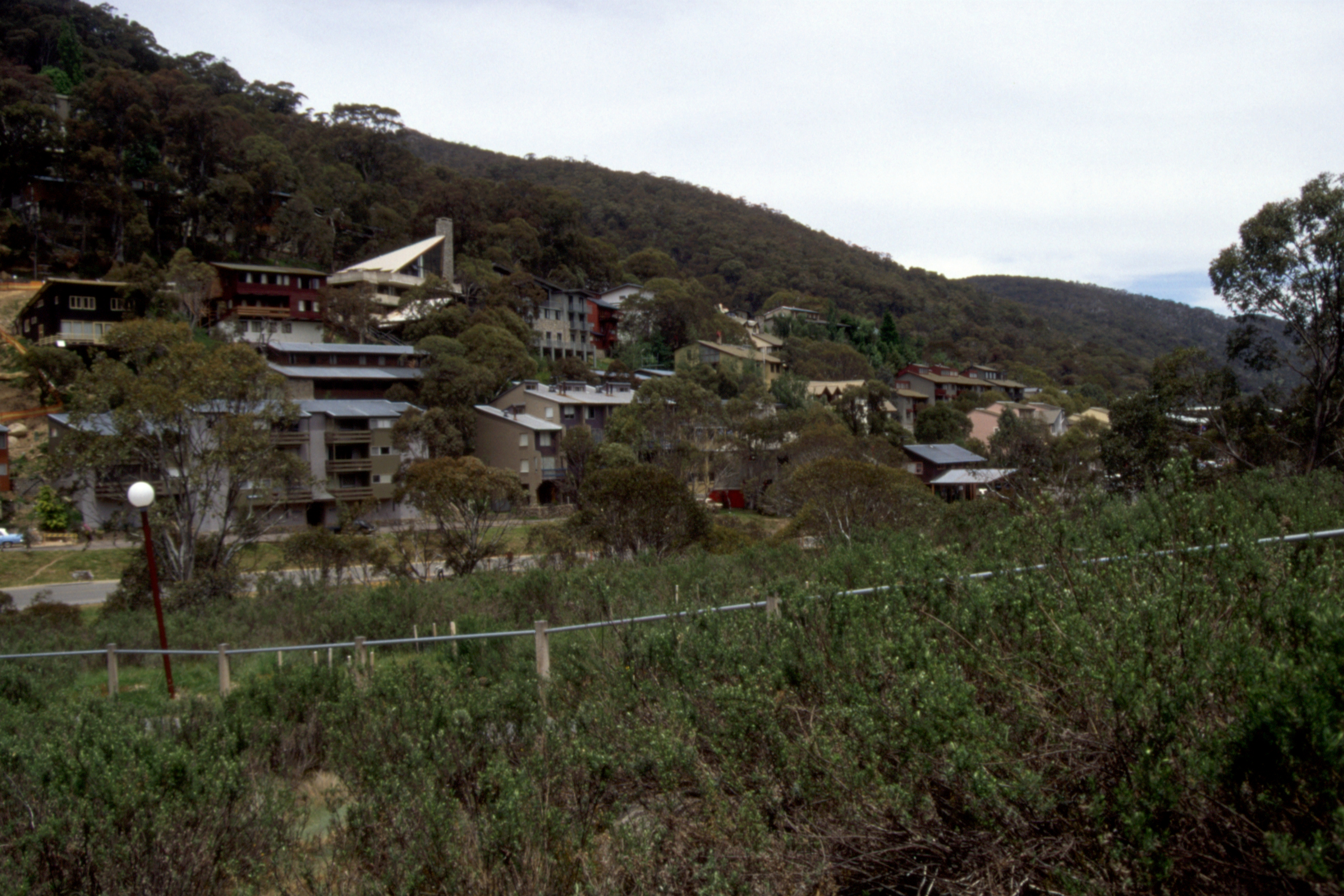
I went for a wander around the (closed) town centre. The town of Jindabyne started life as a work camp for the Snowy River Project, a water management scheme which diverted most of the Snowy River from its natural course which is east and south of the Great Dividing Range, through a tunnel under the mountains to the west for irrigation purposes, generating hydroelectric power on the way. The town is now a ski resort and shuts up shop between the end of the ski season in October and Christmas when the summer holiday trade arrives.
With limited facilities available, I decided to eat Italian and enjoyed an excellent spaghetti gamberetti (baby prawns), and salad (large) with a bottle of Yalumba Galway Heritage 1995. All very nice but a bit pricey, as were the couple of beers I had before bed.
Saturday 29 November — Jindabyne
The breakfast was self-service - fruit juice, cereal, toast and tea or coffee. It was a fine morning and I found the shortest route down to the lake side for a very slow amble towards the town centre. I bought a pint of milk for sustenance before I set about the serious business of trying to buy one or two things I might need in the hills - like waterproof trousers. Some of the shops were shut and those that were open were still in ski season mode - and I got the impression that they just stay that way all summer, in semi-hibernation. The manager of one shop told me that their summer stock was just what was sent up from Sydney.
Having found nothing suitable, I partook of a little liquid refreshment before heading down the main road to inspect the Jindabyne dam. Not spectacular compared to the hydroelectric dams in Scotland but it reduces the famous Snowy River to a miserable Molendinar. (There is now a campaign to have more of the water returned to the natural course to regenerate the river.) I was too lazy to go down to the river so pottered around the top of the dam for a while before making my way back to town following the lake shore as near as I could.
|
|
|
|
| Kalkite Mountain beyond the Lion & Cub Islands |
The dam which blocks the Snowy River | Sluice gates of the dam at Lake Jindabyne |
|
|
|
|
| The impoverished Snowy River | Kalkite Mountain above Copper Tom Reach | The dam which blocks the Snowy River |
I found a cafe for tea and a sandwich (excellent bread) and was meandering back towards the motel when a sudden shower pushed me into the other hotel where courtesy compelled me to have a beer or two while watching several showers go past. When I emerged, another shower pushed me along to the supermarket for some food, then I scurried back to the motel before the rain really started. I gave up all thoughts of going out for a meal and spent the evening rearranging my pack and changing my mind several times about what to do on the morrow to get myself closer to Mount Kosciusko.
Sunday 30 November — The Long Road - Jindabyne to Thredbo
Which was overcast but at least dry. I phoned home, all is well, before setting out fully laden for Thredbo, Australia’s premier skiing resort and the nearest settlement to Kosciusko, Australia’s highest point. My route was along the lake shore for about half an hour to the Snowline Caravan Park where I had a second breakfast (tea and a pie) in the cafe there. The cafe is run by a Thai family and I had some difficulty convincing the young waitress that I did not want sauce with my pie. Just before I was ready to depart, a group of bikers came in and it took some time to settle my bill.
When I picked up my pack to resume my stroll, the stitching on one shoulder strap came away. This was the same stitching I had repaired after my trip to Canada. Luckily, the strap did not come away completely and the harness would continue to function as long as I spread the weight evenly but I would have to remember to pick up the pack with the wrong hand to avoid further damage.
First sighting of snow So, about quarter past eleven, I hit the road for Thredbo – The Alpine Way. The weather had brightened up a bit, without getting too warm and I made short work of the first hill across a spur then it was a gentle drift down into the valley of the Wollondibby Creek After an hour, with a distant view of a hill with some patches of snow, I sat in the shade of a tree (definitely a gum tree but I don’t think it was a coolabah tree) for a while smoking my pipe. By the time I got going again, the light traffic of earlier in the morning had almost dried up and I had the road pretty much to myself.
Another hour walking, another break and then, in the hottest part of the day, I found myself confronted by a horrendous hill, a steady 120 metre rise over 2 kilometres. I was none too pleased when I got to the top and discovered that I had to lose all the height just as quickly descending into the valley of the Thredbo River.
I needed another rest at the bottom and seriously considered hitching but there was little traffic. Another couple of kilometres and, about four o’clock, I reached the National Park toll gate where the lass was kind enough to refill my water bottle. With renewed vigour, I pressed on, walk an hour, stop for fifteen minutes, walk, stop, walk, stop, walk and about quarter to eight I was at the outskirts of Thredbo. That’s where it went wrong.
My intended approach was thwarted by a road closure, the aftermath of a landslip earlier in the year which destroyed a couple of ski lodges. There was a car park beside the river and, without looking again at the map, I reasoned that there must be a walkway into the village. I found a track but it deteriorated and in the end I found myself trapped on the river bank and had to retrace my steps to the car park and take the other road.
So it was almost half past eight when I reached the hostel, checked in for three nights, had a shower and went to bed. 35 kilometres on the road and just a little sunburn.
Monday 1 December — Thredbo
Kerry at the hostel got me a weather forecast, much the same for the next three days, so there was no pressure to rush up Kosciusko and I decided to have a rest day. After an expensive breakfast in a cafe (milkshake, granola (muesli, which I didn’t manage to finish) and tea), I phoned to arrange a bus for Canberra for Wednesday. (If there are no passengers, the bus does not run!) The 1800 (free) number advertised just gave another (not free) number to call but I got through to that and had no difficulty making the reservation.
I wandered around the village for a while, taking in what few sights there are (not that many are needed with so much scenery around) then bought some supplies from the supermarket and dumped them back at the hostel. Just to keep my joints from seizing up, I walked a few kilometres up the Dead Horse Gap track, following the Thredbo River, pleasant enough but not much excitement.
 |
 |
 |
| Site of the Thredbo landslip | West end of Thredbo Village | Thredbo town centre |
Back in town, I discovered that the earliest pub opening was four o’clock so had another walk round the village before a couple of pre-prandial beers. I dined on tinned Irish Stew and fruit salad before reading a bit, writing a bit of this diary and retiring to bed.
Tuesday 2 December — To the Top of Australia
I decided to cheat and use the chairlift for the first 500 metres of the climb. which is the steepest part of the ascent and, as it turned out, the only part which could be described as steep. Since the chairlift did not start running until nine, I had time for a leisurely breakfast of tea and carbohydrate before heading over to the chairlift bottom station, where I bought a one-way ticket (a triumph of avarice over common sense, as usual) and was the first fare-paying passenger to go up. The usual summer lift, the Crackenback, was undergoing maintenance so the slightly shorter Snowgums lift was in use. In 16 minutes, I gained 450 metres in height and had almost reached the plateau.
Ten minutes up the service road to the top of the Crackenback lift where I made use of the toilet before continuing on a brick paved path for 500 metres to the start of the elevated walkway. This is the local answer to the problem of erosion on a popular walk. The track is a tight metal grating raised about a foot off the ground on metal stanchions. The grating allows light and precipitation to pass through, minimising damage to the vegetation and it reduces the pressure of snow in winter. It does look a bit strange, a dark ribbon stretching four kilometres across the hill, but judging by some old patches of erosion, something had to be done.
 |
 |
 |
| Thredbo Village from the top of the Crackenback Chairlift |
Looking east down the Thredbo River valley |
First view of Mt. Kosciusco (2228m) from the Kosciusco Lookout |
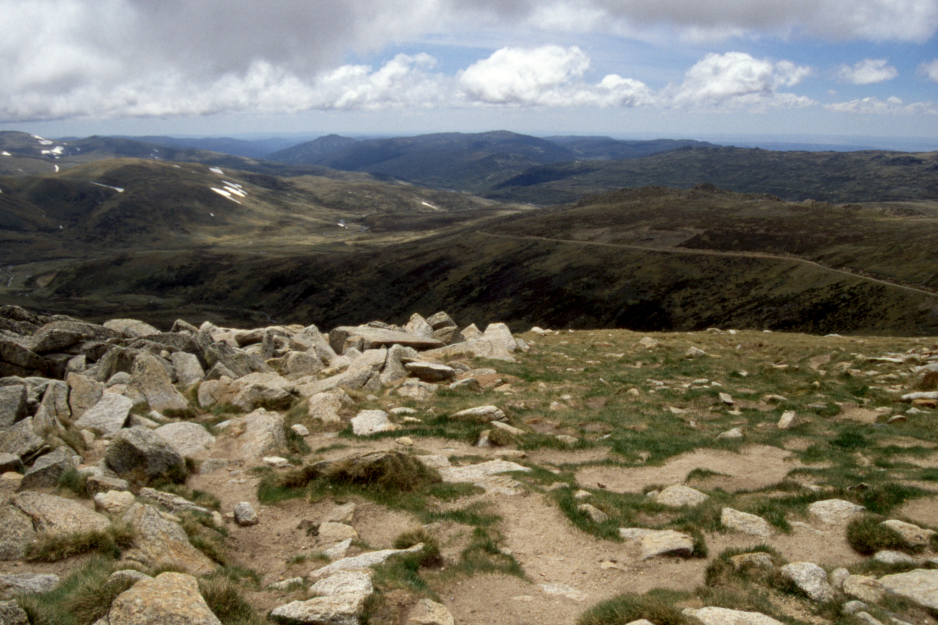
The walkway led past Lake Cootapatamba (probably the highest lake in Australia) to the Summit Service Track (a reasonable road up from Charlotte’s Pass) at Rawson Pass just above 2,100 metres from where a slightly rougher track provided access to the summit. Hardly a challenging climb but at 2,228 metres (7308 feet), somewhat higher than I had been for several years.
 |
 |
 |
| Looking down the North Arm Snowy River from Rawson Pass |
Looking north to Mt. Townsend (2209m) from the summit of Mt. Kosciusco |
The old track at the summit of Mt. Kosciusco looking east over Rawson Pass. |
The weather was dry but mostly overcast, with a strong wind and cloud coming and going just at summit level. The view to the west was not dramatic, the ground fell away gradually to the vast plain that is the centre of Australia and a slight haze softened everything. I did manage a few photographs when the cloud lifted a bit.
 |
 |
 |
| Looking west towards Perth from the summit of Mt. Kosciusco |
Looking WNW towards Charlotte's Pass from the summit of Mt. Kosciusco |
Summit markers on Mt. Kosciusco (2228m) |
By half past eleven, it was time to move on and I set off along the Main Ridge Walk (or Lakes Walk depending on whether you believe the signs or the map) to Meuller’s Peak which afforded a reasonable view back to Kosciusko and a better view over Lake Albina.
 |
 |
 |
| Looking south to the top of Mt. Kosciusco from Mueller's Peak (2100m), Ram's Head on the left |
Albina Lake, just north of Mueller's Peak | A young Snowy River |
I returned by the same route, including the Kosciusko summit, and reached the top of the chairlift about quarter past three, just before the lift closed at half past. But, I had not bought a return ticket so I decided to follow Merritt’s Nature Track back down to Thredbo. This proved a good decision. The track was well made, including some sections of 4WD road (the chairlift service road, I think) with good views over the valley and a profusion of wild flowers along the way. So profuse were the wild flowers that I came to the conclusion that they had been “managed”, to very good effect.
 |
 |
 |
| Lake Cootapatamba below the Kosciusco South Ridge |
The Kosciusco anti-erosion solution crosses the Etheridge Gap |
A source of the Snowy River crossed by the Kosciusco track |
 |
 |
 |
| Man proposes but is shaped by Mother Nature |
A source of the Snowy River crossed by the Kosciusco track |
The Kosciusco track passes a lingering patch of snow as it snakes down towards the chairlifts |
It was about half past four when I reached Thredbo and returned to the hostel for a shower and pot of tea to rehydrate before going in search of beer and a meal. However, the House of Ullr was pretty busy so I settled for the beer and than had another in the Bistro for afters.
Wednesday 3 December — Thredbo to Canberra
Thredbo skifield chairlifts
I had prepared my pack last night so had a straightforward departure from the hostel and was in good time for the bus. Which is more than can be said for the other passenger - who had set his alarm wrongly and had been wandering around thinking he still had an hour to spare! Anyway, he was only five minutes late and we were off before nine. It took half an hour to cover the 35 kilometres to Jindabyne that I had taken me all day on foot on Sunday. After a brief stop at Cooma, we arrived in Canberra at quarter to twelve where I booked into the City Walk Hotel (a budget hotel with backpacker accommodation) for three nights. (It is closer to the centre than the YH.)
The bookshop at the bus station had a good selection of maps, including a town plan of Aberdeen, but no map of Canberra. The information desk provided me with a “What’s On” booklet which had a map of the centre and I set off for Black Mountain (against the advice of the lassie at the information desk who reckoned it was far too hot for walking). Without a map, I had to stick to the roads (and footpaths through the university) as best I could remember them from ten years before, with a little help from the tower itself being a prominent landmark.
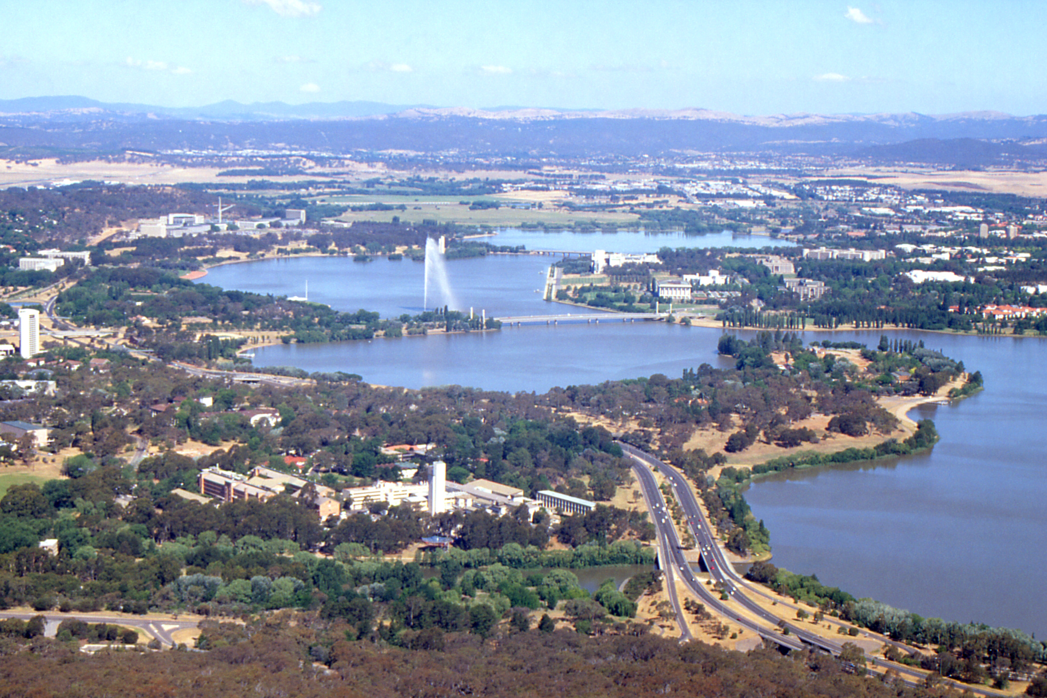
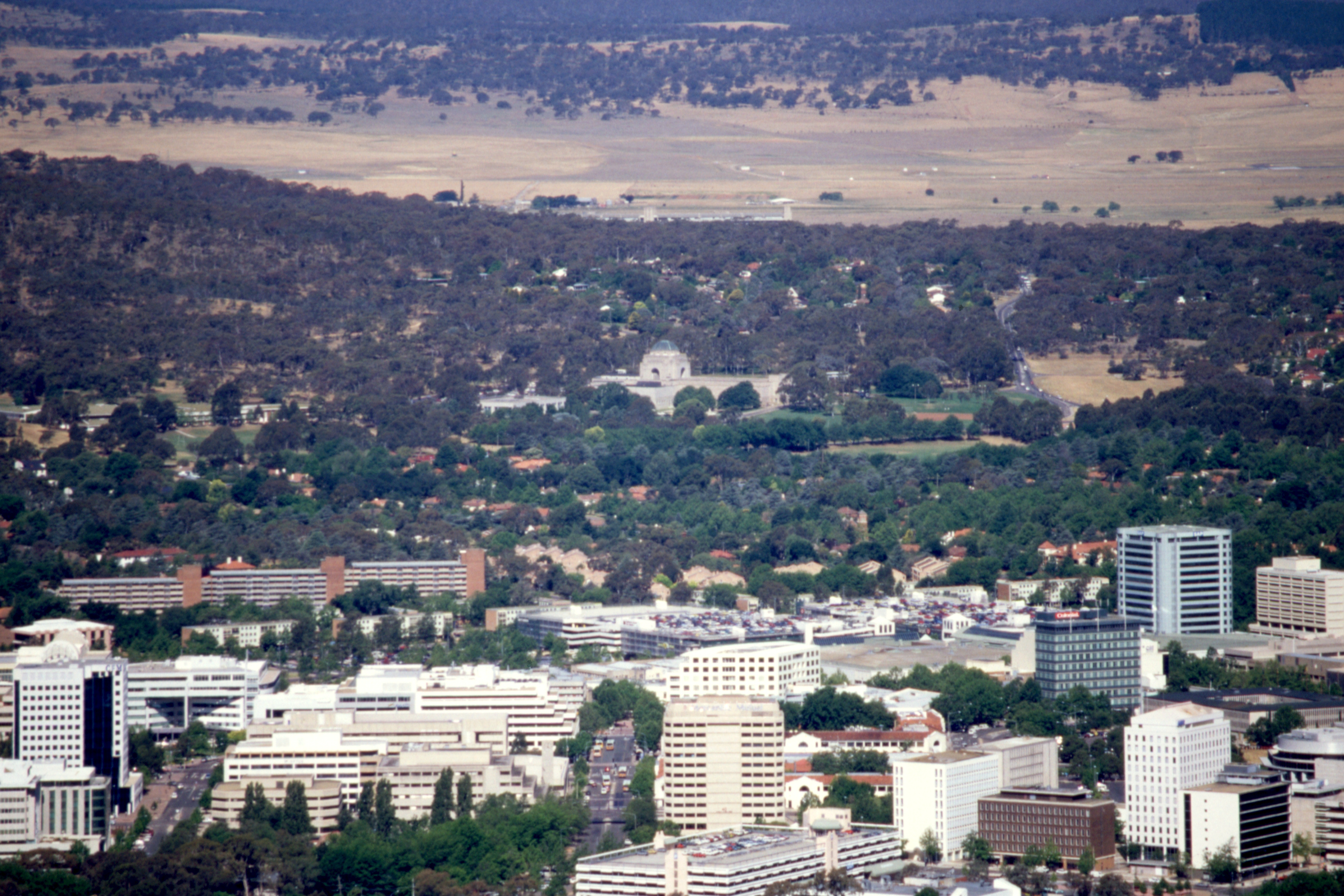
Black Mountain is the site of the Telstra (formerly Telecom) Tower, not too high itself (only 195 metres) but being atop a small hill, it affords fine views over the city, and has a tea-room where I partook of a Devonshire Tea (they had no apple pie!). Afterwards, I circumnavigated the car park and found the top of the footpath which offered a more pleasant route back down to the university.
 |
 |
 |
| Lake Burley Griffin from the Telstra Tower |
The Captain Cook Memorial Jet ... | ... in Lake Burley Griffin |
 |
 |
 |
| The Australian Federal Parliament Building | The National War Memorial beyond Downtown Canberra |
Looking south over Lake Burley Griffin |
 |
 |
 |
| Belconnen and Lake Ginnenderra |
National Library, High Court and National Gallery | Mount Ainslie and the Civic Centre beyond the University |
 |
 |
 |
| The slope of Black Mountain and the Civic Centre | West end of Lake Burley Griffin | Telstra Tower atop Black Mountain |
Back at the hotel, I phoned Dirk, who was not otherwise occupied and we arranged to meet in an adjacent hostelry. He arrived accompanied by his son Mike and we had a pleasant evening reminiscing on the days that are gone.
Thursday 4 December — Canberra
I still haven’t got this breakfast thing sorted out. I don’t know why I end up ordering bacon and eggs when all I want is cereal and fruit juice.
After breakfast and a litre of milk, I wandered over to the War Memorial Museum and made some enquiries about our photographs of Australian soldiers. They were very helpful about the uniforms, directing me to a poster in the shop where I might compare shoulder flashes, but did not offer to throw open the archives to find the home addresses. (I have since discovered that the archive staff are even more helpful when approached through the proper channels.)
 |
 |
 |
| Courtyard of the Australian National War Memorial |
The view from the National War Memorial, down Anzac Avenue, across Lake Burley Griffin to the Old and New Parliament Houses |
Cook Memorial Fountain with the Telstra Tower on Black Hill |
The day was very warm and hazy so I decided against going up Mount Ainslie to admire the view and drifted back into town and found a pub, the Wig and Pen, which brewed its own beer, including a passable Pass Porter and a reasonable Bulldog Best Bitter but I wasn’t too impressed with the Ballyragget Irish Red.
In the evening, I phoned Dirk and arranged to dine and stay overnight with him tomorrow. My usual evening haunt, the Oval Bar, was rather noisy - Pandora’s, the disco upstairs, was open.
Friday 5 December — Canberra
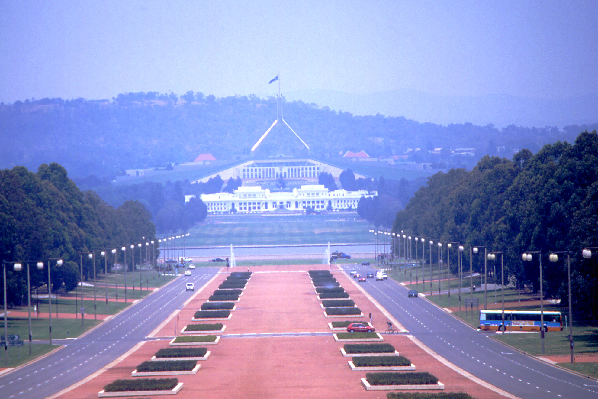
I started the day with a pint of milk then tea and a large currant cake in the food court in the basement of the Canberra Centre (a shopping mall), before walking round Lake Burley Griffin past the National Carillon on Aspen Island, over the King’s Avenue bridge and along to the old Parliament House then up the hill to the new one. I’ve said it before and I’ll say it again, this is a wonderful building, with a lawn over the top to emphasise its integration with the hill. I admired the view for a while before returning to the city centre via Commonwealth Avenue and the other bridge across the lake.
 |
 |
 |
| The Carillon on Aspen Island, a gift from the UK to mark Canberra's Golden Jubilee in 1963 |
Lake Burleigh Griffin | Old Parliament House with the spire of New Parliament House rising above |
 |
 |
 |
| From in front of New Parliament House towards the National War Memorial and Mount Ainslie, Landscaping hides the Old Parliament House |
New Parliament House, Canberra, pity about the parked cars |
The top of Old Parliament House, National War Memorial and Mount Ainslie from the roof of New Parliament House |
 |
| Commonwealth Avenue from the roof of New Parliament House |
I had time for another pint of Bulldog Bitter before heading for my rendezvous with Dirk beside a filling station. I was peering up and down the street looking for his car when I heard a shout from behind me. He was already there filling the car. He took me for a wee tour, up Mount Ainslie (much easier than walking up) which affords an excellent view over the top of the National War Memorial, down ANZAC Parade and across the lake to the two Parliament Houses. We then went down to the recreational end of the lake and I admired Dirk’s favourite wind surfing spot before passing through Yarralumla, the diplomatic district, to admire various embassies and high commissions before heading out to Pearce.
 |
 |
 |
| ANZAC Parade, Lake Burley Griffin and the Old and New Parliament Houses from the top of Mount Ainslie |
After a cup of tea, we crossed the road and wandered up and round the local eminence, Mount Taylor, to admire more views. Celia and Mike were in when we got back to the house and another cup of tea was produced. I admired the air conditioning arrangements - what back home would be a convection heater - has the elements removed and a tray installed where one can place a block of ice. Then we went down to the local curry shop, Roma’s, for a very pleasant evening. In honour of the occasion, I wore trousers for the first time since leaving home.
 |
 |
| Canberra suburbs from the top of Mt. Taylor |
Pearce, towards Woden Centre & Black Hill |
 |
 |
 |
| More Canberra suburbs from Mt. Taylor |
The suburb of Pearce from Mt. Taylor | Another view Mt. Taylor |
Saturday 6 December — Canberra to Albury
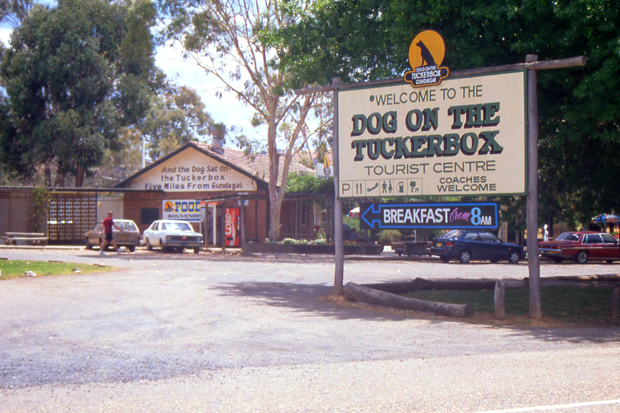
After a leisurely start to the morning, Dirk drove me in to Jolimont, the Canberra bus station, for the bus to Albury at ten past eleven. About one o’clock, we stopped for lunch at a roadhouse seven kilometres from Gundagai, imaginatively named “The Dog on the Tuckerbox” (a bowdlerised reference to a well known traditional song lamenting an unfortunate event which occurred five miles from Gundagai). The roadhouse is a veritable tourist trap, unashamedly milking the only claim to notoriety ever to have befallen this otherwise unremarkable district. I spent no money, contenting myself with a visit to the toilet and a couple of photographs.
 |
 |
| Tourist trap road house five miles from Gundagai |
Statue of the dog which “sat” on the tuckerbox |
We reached Albury at ten to four and I found a convenient backpackers, the Murray River Lodge, where I booked in for three nights. I headed down to the river bank to check the sailing schedule for the Paddle Steamer Cumberoona for the morrow before having a wander round the town interspersed with a quick refreshment of an alcoholic nature in some of the local pubs.
[ next chapter ]
John Reynolds — April 2014

